El Nino Saat Ini Lampaui Rekor 1997, Curah Hujan di Indonesia Diprediksi Menurun
El Nino is a Record Breaker: Phenomenon has Smashed 1997 Record in Past Three Months
Editor : Ismail Gani
Translator : Novita Cahyadi
EL NINO yang berlangsung saat ini tergolong yang terkuat yang pernah tercatat, seperti dinyatakan pakar iklim dan cuaca.
Sistem cuaca, yang dipicu oleh peningkatan suhu permukaan laut di Samudra Pasifik, telah memecahkan rekor 1997 dalam tiga bulan terakhir.
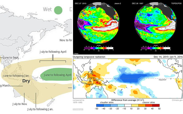
Hal ini merujuk pada laporan yang dilansir oleh National Oceanic AS dan Badan Atmosfer (NOAA) bahwa air di Samudera Pasifik Tengah mencapai 3,1° C di atas rata-rata pada 18 November.
Yang secara signifikan lebih tinggi dari 2,8°C yang tercatat selama El Nino pada 1997-1998.
Tahun ini El Nino mengakibatkan lapisan air hangat yang biasanya menumpuk di sekitar Australia dan Indonesia secara drastis menipis, sementara iklim tropis melanda Samudera Pasifik bagian timur, permukaan perairan yang biasanya dingin kini diselimuti lapisan tebal air hangat.
Meningkatnya suhu panas menyebabkan suhu air laut meningkat dari Pasifik tengah ke Amerika.
Hal ini mengakibatkan penurunan intensitas hujan di Asia Tenggara, mengurangi curah hujan di Indonesia dan memberikan kontribusi terhadap meningkatnya kebakaran hutan yang berlangsung masif tahun lalu.
Kini, hasil penelitian terbaru oleh Jan Null, seorang pakar meteorologi di Layanan Cuaca Golden Gate di Califonia, menyodorkan data akurat.
Pakar meteorologi ini mengukur El Nino berdasarkan betapa hangatnya bagian dari Pasifik tengah selama tiga bulan berturut-turut. Catatan kembali ke 1950.
"Kami memiliki cukup banyak data yang diperoleh sejak akhir musim panas, berlangsung lebih awal dan ini pertanda akan menjadi El Nino yang sangat kuat," kata Null kepada New Scientist seperti dilansir MailOnline.
Hasil penelitiannya mendapati bahwa tiga bulan terakhir tercatat dampak ´yang sangat kuat pada 2,31 di indeks samudera Nino.´
Hal ini menunjukkan sebagai pertanda terjadinya anomali pada suhu permukaan laut dan dibandingkan dengan 2,26 yang sebelumnya tercatat sebagai dampak terkuat El Nino pada 1997.
lPara ilmuwan meyakini fenomena cuaca telah mencapai puncaknya, dan secara bertahap akan menghilang dalam beberapa bulan ke depan.
Namun para peramal cuaca memperingatkan bahwa meskipun mereka berharap anomali permukaan suhu laut suhu di Pasifik tropis berkurang secara bertahap, ´masih ada kemungkinan lain yang bakal terjadi.´
Untuk kawasan Amerika, mereka memperingatkan efeknya ´baru dimulai´.
´El Nino mencatat peningkatan yang cukup mengesankan pada bulan Desember, dan kami mendukung transisi ke kondisi netral pada akhir musim semi atau awal musim panas." Kata Emily Becker dari NOAA.
THE PRESENT El Niño is the strongest ever recorded, scientists have confirmed.
The weather system, which is triggered by a warming sea surface in the Pacific Ocean, has smashed its 1997 record in past three months.
It follows news by the US National Oceanic and Atmospheric Agency (NOAA) that water in the Central Pacific Ocean reached 3.1°C above its average on November 18.
That is significantly higher than the 2.8°C recorded during the 1997-1998 El Niño.
This year´s El Niño has caused the warm water layer that is normally piled up around Australia and Indonesia to thin dramatically, while in the eastern tropical Pacific, the normally cool surface waters are blanketed with a thick layer of warm water.
This massive redistribution of heat causes ocean temperatures to rise from the central Pacific to the Americas.
It has sapped Southeast Asia´s rain in the process, reducing rainfall over Indonesia and contributing to the growth of massive wildfires that have blanketed the region in choking smoke.
Now, a new study by Jan Null, a meteorologist at Golden Gate Weather Services in California, has backed that data.
Meteorologists measure El Nino based on how warm parts of the central Pacific for three consecutive months. Records go back to 1950.
´We have pretty much had it nailed since late summer, early fall that this was going to be a very strong El Niño,´ Null told the New Scientist.
His study found that the past three months score ´a very strong 2.31 on the oceanic Niño index´.
This is one of the primary measures of anomalies in sea surface temperatures and compared to 2.26 for the previous strongest El Niño in 1997.
Scientists believe the weather phenomenon has reached its peak, and will gradually die out over the next few months.
But forecasters have warned that even though they expect the sea surface temperature anomalies in the tropical Pacific to decrease gradually, ´there is still a lot going on´.
For America, they warn the effect is ´just beginning´.
´El Niño put up some pretty impressive numbers in December, and we´re favouring a transition to neutral conditions by the late spring or early summer.´ Emily Becker of the NOAA said.